We hope that each of you, our readers, will greatly enjoy and appreciate this article about these 3 Choice Features of Chile. It was certainly our great pleasure to compile the information for you. May it provide you with both education and increased awareness.
Certainly, however, these few features listed herein represent only a portion of the marvels found in this region. It’s our belief, though, that they serve as excellent representations of the wonders that abound here. Check out our other articles for similar sites.
Villarrica
Villarrica Facts
- Leading off this article about these 3 Choice Features of Chile we present the magnificent location best known simply as Villarrica.
- The short term given it serves as the most frequently used name for this impressive creation of long-term geological forces. This moniker, however, originates in the Spanish Language. It doesn’t represent the original term first applied to the marvel.
- This remarkable formation also has a few other names, though. Those derive from the Mapuche and Mapudungun languages. That’s because it also bears the short names of Rucapillán and Ruka Pillañ, in the native tongues of these local Indigenous Peoples.
- The native inhabitants of the region long knew of its presence, of course. How long remains a mystery. The first sightings of it by Europeans, however, likely occurred in the mid-16th century. The first recorded mention of it refers to an eruption in 1552.
- It’s also maintained an active status. In fact, this volcano ranks as one of the most active in its region. Due to this, it holds great importance to scientific research. It’s one of 9 volcanos currently being monitored by the Deep Earth Carbon Degassing Project.
- Given this level of activity, human activities on Villarrica face potential threats. Despite this, however, many people come to view the mountain. The site’s closely monitored therefore, and visits are forbidden if experts believe eruptions to be imminent.
Villarrica Physical Description
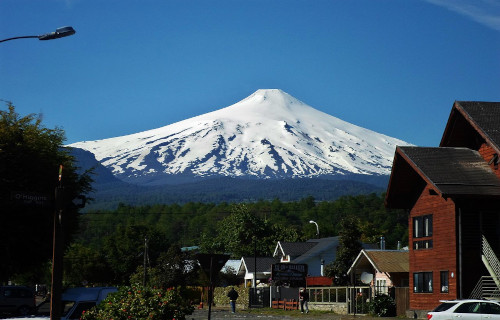
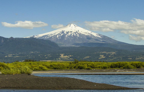
The astonishing Villarrica stands out from the surrounding landscape. It also merits attention for several reasons. That’s due in part to the fact that its mere height constitutes only part of its size. The mountain actually consists of far more than just the beautiful cone.
That’s not to say that feature isn’t impressive in itself, though. The nearly perfect cone has a summit that measures a remarkable 5,167 ft (1,575 m) above the surrounding terrain. The top of the volcano further has an amazing elevation of roughly 9,380 ft (2,860 m) above sea level.
This masterpiece of volcanic forces actually covers a large area, however, That’s due to the fact that, after the cone itself, its sides slope gently downward and outward, to a vast distance. The mountain itself thus actually covers a total area of 154.4 sq mi (400 sq km)!
It also boasts an impressive volume, because of its area of coverage. Though experts can’t be certain, estimates place its volume at approximately 60 cubic mi (250 cubic km). This area itself also serves as home to a wide variety of smaller, though likewise remarkable, features.
The main body of the marvelous Villarrica holds many fascinating smaller, though equally wondrous, features to behold. These include several volcanic caves, and an abundance of smaller scoria cones. Amazingly, its upper regions also hold several small glaciers.
Villarrica Location, Formation, and Eruptions
The stunning volcano named Villarrica formed in a region of the globe well known for its abundance of geological wonders. Many of those marvels consist of features similar to this one. That’s because it formed on what’s now known as the continent of South America.
More specifically, though, it lies within the boundaries of what’s now the country of Chile. It its roughly 470 mi (756 km) south of Santiago. This location additionally places it in the southern portion of the country, as well as the far southern part of the continent overall.
Scientists remain uncertain of the precise timeframe for its creation. Most estimates, however, place its original formation at sometime between 1 -2 million years ago. It also sits atop an old fracture in the earth’s crust, known as the Mocha-Villarrica Fault Zone.
During a particularly powerful eruption, around 100,000 years ago, it took its current general shape. At that time, however, its caldera measured an astounding 4.03 x 2.6 mi (6.5 x 4.2 km)! This collapsed once again, about 13,700 years ago, into a much smaller size.
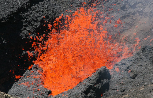
The modern-era eruptive history of Villarrica began in 1552. During the following decade, it erupted numerous times. Though most were relatively small eruptions, like Stromboli, the original one during that period deposited layers of ash up to 124 mi (200 km) away.
It remained comparatively quiet after the 17th century, with only very small rumblings on occasion. The powerful stratovolcano returned to a more active status in 1963 and 1964, though. Since that time, it’s experienced dangerous eruptions in 1971, 1972, and 2015.
Laguna Verde
Laguna Verde Facts
- Next up among our choices for inclusion in this listing of 3 Choice Features of Chile comes the mesmerizing beauty of Laguna Verde.
- In the native language of the region in which it formed, this breathtaking body of water most frequently goes by the name we use here. This translates into english literally as green lake. The name’s certainly descriptive, and appropriate for the formation.
- Despite its extreme beauty, tourist activity in the region remains limited, though only in relative terms. It actually ranks among the most frequented of locations for tourist visits in the country in which it lies. The reason for that’s relatively simple, however.
- The body of water lies within the confines of the Eduardo Avaroa Andean Fauna National Reserve. This makes it a somewhat remote destination. However, the fact that this places the lake in the approximate middle of the Andes further limits visitation.
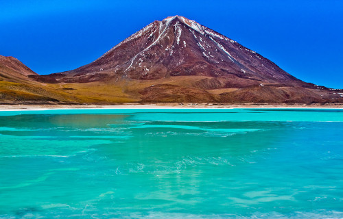
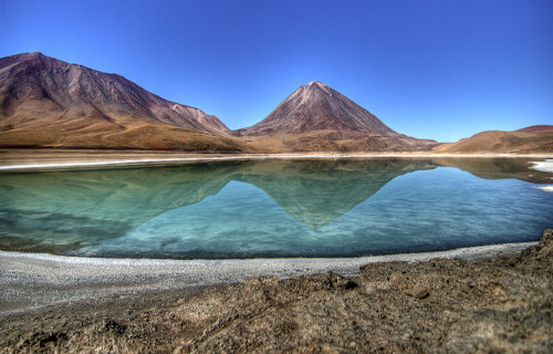
- Augmenting its visual appeal further is the surrounding landscape, as one can plainly see from this image. That’s because it clearly lies at the base of a majestic mountain. That mountain, though, is actually the volcano bearing the name of Licancabur.
- Being presently considered as dormant, having this as a backdrop merely enhances the magnificence of Laguna Verde. The combination leaves the site generally considered by many to be among the greatest geological marvels of this region of the globe.
Laguna Verde Physical Description
The mesmerizing beauty of Laguna Verde exists on its own merits, wholly regardless of any other physical characteristics. That fact’s plainly obvious to any and all who visit its shores. Yet its other traits bear mentioning in any discussion of the amazing site, of course.
The incredible body of water further has a highly elongated overall shape. It also has an irregular, and somewhat variable, outline. The lake’s further divided into two sections by a relatively narrow causeway. This provides it with a stretched-out figure eight shape.
It also manages to compress such natural beauty into a small site. That’s because, aside from that appeal to the eye, its other attributes remain modest. Thankfully, though, Nature has never felt restricted to combining size and beauty in its many constructions.
The marvelous Laguna Verde possesses a total average surface area of approximately 2.9 sq mi (7.5 sq km). This varies slightly, of course, due to such factors as rainfall and evaporation rates. It remains quite shallow, however. It also has an average depth of 18 ft (5.4 m).
Its the tantalizing hues of the body of water that garner the most attention, however. This comes from the suspension of high levels of several minerals, including arsenic! This thus results in a range of brilliant colors that varies from turquoise to a dark emerald shade.
Laguna Verde Location, Formation, and Nature
The eye-catching lake known appropriately as Laguna Verde formed in a region of the globe well known for its abundance of geological marvels. That’s due to the fact that natural processes created it in an area of what now constitutes South America.
More precisely, the lake sits in the country of Bolivia. It’s also quite close the border with the country of Chile. This places the natural wonder in the Sur Lípez Province of the Potosí Department. This places it in a remote, and comparatively rugged, region.
Technically considered a salt lake, it further formed in a naturally occurring drainage basin, quite close to the dormant volcano that so dominates the local skyline. It also sits at an astounding altitude of 14,140 ft (4,310 m). Snowfall therefore forms part of its source.
The majority of its water, however, comes from another source. Geothermal activity still present beneath the site provides it with a natural inflow of water from hot springs. Despite the altitude, its water therefore maintains an average of 55-68 F (13-20 C).
Due to the slight toxicity of its waters, wildlife is absent from Laguna Verde. It nevertheless has other marvels to draw the tourist, in addition to its green shade. Numerous geological structures, known as stromatolites, dot the region, though they’re now inactive.
Researchers estimate that these structures formed between 20,000-10,000 years ago, though. Presently, however, other, smaller structures of a different nature still appear. These consist of microbial mats, formed by the actions of specialized bacteria in the water.
Atacama Desert
Atacama Desert Facts
- Closing out this compendium of 3 Choice Features of Chile is the starkly beautiful location best known as the Atacama Desert.
- In terms of desert-like features, this absolutely breathtaking feature puts even other desert regions to shame! That holds true for several reasons, in fact. First and foremost, this stunning work of Nature ranks as the driest non-polar desert on earth.
- It bears noting that, by definition, a given region qualifies as a desert if its evaporation rate exceeds that of its rate of precipitation. That’s why certain polar regions qualify as deserts, to the surprise of many individuals, believing that desert areas must be hot.
- This wonder of Nature is also the oldest known desert on earth, by far. Evidence places its origins as far back in history as 20 million years, at least. Its extreme nature, as it exists today, however, appears to have only existed for around 3 million years, though.
- Yet its status isn’t earned simply due to this one factor. The stark section of the globe also qualifies as a unique variety of desert, known as a fog desert. That title’s earned when a desert region receives the majority of what little moisture it gets from fog drip.
- The distinctiveness of the fabulous, if stark, Atacama Desert does not go unnoticed or unappreciated by those who value Nature. As a result, portions of the site form a total of 3 protected areas. Sadly, though, these cover only a fraction of the regions total area.
- The sections set aside for protection form either National Parks or National Reserves. They bear the names of Pan de Azúcar National Park, Pampa del Tamarugal National Reserve, and La Chimba National Reserve. Other areas serve as experimentation sites.
Atacama Desert Physical Description
The magnificent Atacama Desert has a distincitve shape, in addition to its other outstanding features. That’s because this stark wonder of Nature has a highly elongated shape. Although its edges are naturally irregular, it’s average measurement is roughly 10 times as long as wide.
More precisely, its average length measures nearly 700 mi (1,120 km). The average width, however, only equals approximately 60 mi (96 km). Both these dimensions vary, of course, due to various environmental factors, though rarely to any significant degree.
These average dimensions give it a total area of roughly 41,000 sq mi (105,000 sq km). Some accounts provide a slightly greater area, though, due to differences in definition. That’s due to the fact that the other calculations include the barren slope of surrounding mountains.
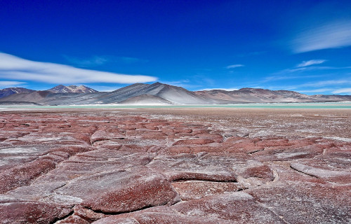
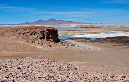
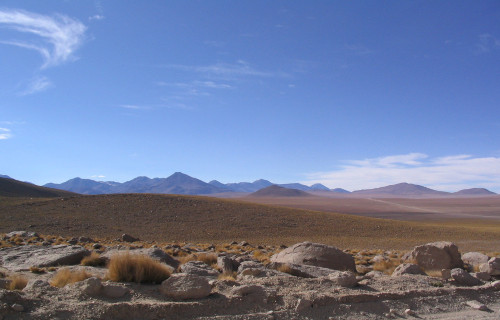
Much of the astonishing Atacama Desert has an otherworldy appearance. This holds true due to the existence of an unusual, and distinctive, combinations of terrain. These include such varied features as salt lakes, stony terrain, ancient lava flows, and of course, sand.
Amazingly, its borders, of all things, qualify as yet another distinguishing characteristic. That distinction occurs because, firstly, on one side its bordered by now one but two mountain chains. And on the other side, to the amazement of many who see it, lies an ocean!
Atacama Desert Location, Formation, and Ecology
The awe inspiring Atacama Desert did not form in a part of the world that most people would expect to find such an extensive desert region. One the contrary, most of the rest of the continent on which it formed remains widely known for its verdant nature.
That’s because this marvel of natural processes formed on what now constitutes the continent of South America. More precisely still, the fabulous site lies on the Pacific coast, slightly west of the mighty Andes Mountains, within the borders of the country of Chile.
The conditions which formed it arose, and are maintained by, a constant temperature inversion. This occurs due to the presence of the Humboldt ocean current, along with a powerful semi-permanent Pacific weather pattern, commonly known as an anti-cyclone.
The driest part of the region lies between the Chilean Coast Range and the towering Andes. Their great height prevents virtually all flow of moisture from either the Atlantic Ocean or the Pacific Ocean. This portion receives an average of only 0.6 in (15mm) of rain per year!
Despite the conditions, life found a way to survive here, and some even flourish. More than 500 species of flora call the region home. These mainly consist of various herbs, along with several small flowers. Several types of trees, and numerous succulents also appear.
Few species of fauna live in the Atacama Desert, but a few manage it, mainly along the fringes. These include insects, such as grasshoppers and beetles. A few types of scorpions and lizards also dwell in its confines. Amazingly, many birds live along the ocean coastline.
3 Choice Features of Chile
We truly hope that you have all completely enjoyed reading, and hopefully learning from, this article about these 3 Choice Features of Chile. It’s also our fervent hope that doing so has left with a new or renewed appreciation for such marvels of Nature.
Lamentably, however, many of the similar sites on the planet now find themselves facing dire threats to maintaining their pristine condition. Most of those stem either directly or indirectly from the actions of man. We must now do all we can to preserve them.
Check out our other articles on 7 Spectacular Atlantic Ocean Species, 5 Tantalizing Mammals of Tasmania, 7 Fabulous Philiipines Fauna, 6 Magnificent Moths of Canada


Leave a Reply